|
|
|
 |
The Brief
Horton Levi Ltd carried out an aerial
heat-loss survey on behalf of
Chester-le-Street District Council. In
order to make best use of the data, the
Council required a geo-rectified image map
capable of overlaying their existing
map/landline data and aerial imagery.
In this instance, the end product had to be
compatible with CadCorp, OSMastermap and Mr.
Sid imagery files. |
|
 |
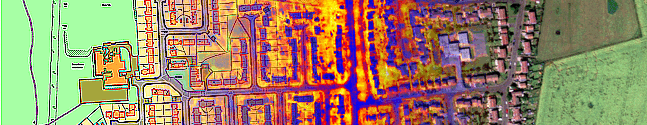
Stage 1 -
data collation
We were provided with just under 2,300
individual thermal image files by Horton
Levi in bitmap (.bmp) format, together with
landline and sample imagery data. The
District area is largely rural, but contains
the towns and villages of Chester-le-Street,
Great Lumley, Sacriston, Pelton, Oulston,
Bournmoor, Kimblesworth and Edmondsley.
Our aim was to georectify and mosaic the
entire district to create a seamless map -
the total area amounted to approximately
80km². |
|
 |
Stage 2 -
data formatting
The landline data was provided in
OSMastermap compressed .gz format. We
extracted this to .gml format and then
converted the entire map to a shape file for georectification purposes.
Likewise, we
converted the thermal data from .bmp to .tif,
cropped each image and approximately
re-orientated them to North where necessary. |
|
 |
Stage 3 -
georectification of aerial data
Each image was individually rectified.
In practice, this means that reference
points, known as Ground Control Points (GCPs)
were plotted on each image and then their
precise matching point was plotted on the
map data. We estimate that
approximately 21,000 GCPs were plotted in
total - averaging 262 per 1km². This
ensured remarkable levels of accuracy in
Stage 4.
Due to the rural
nature of the survey area, large parts of
the map were fields and farmland, much of
which is difficult - and at times impossible
- to rectify against map data. However
we developed a system allowing us to do just
this, ensuring that there was not a single
gap in the data.
|
|
 |
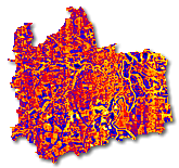
Stage 4 -
Constructing the final data map
With all the data rectified, we began the
task of producing a complete data map.
Each image is stitched and blended together,
producing a seamless mosaic of the entire
area.
The data was projected using British
National Grid co-ordinates so that it would
precisely overlay both the landline data and
aerial photography. |
|
|
Stage 5 -
Presentation of Data
The completed product was provided in three
formats on DVD:
- GIS
compatible to form an additional layer
in the Council's mapping system
- GIF and
JPG format for global viewing and
presentation purposes
-
Individual image files in original
greyscale and colourised for heat-loss
analysis
|
|
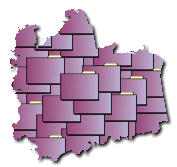
We join together aerial
photographs to form a seamless
image |
|